
Bicycle & Pedestrian Network Plan
The City of Newburyport has developed several lists of proposed and planned street and sidewalk improvements, including the Sidewalk & Curb Ramp GIS-based Inventory/ Assessment (2017), a Complete Streets Prioritization Plan (2019), and a Roadway and Sidewalk Plan (2022, updated 2024). However, these are all lists of discrete projects and do not look at the overall transportation network in the City.
To respond to this need, Newburyport Livable Streets spent several months in early 2023 developing a Bicycle & Pedestrian Network Plan, which we submitted to the Mayor’s Office in April 2023. This Plan identifies the major links, nodes and gaps in Newburyport’s bicycle and pedestrian network and proposes measures to eliminate the gaps, improve safety and comfort, and complete the network. Beyond a list of discrete projects, the Bicycle & Pedestrian Network Plan looks at the entire network. It is organized both in terms of priorities and geographically, so that City officials and residents can consider project priorities within neighborhoods and districts and as components in the overall transportation network.
Goals and Priorities
In developing the Bicycle & Pedestrian Network Plan, we were guided by four goals:
1. Provide convenient connections to daily destinations
2. Improve safety and comfort for all users
3. Provide equitable access for all neighborhoods
4. Support city climate resiliency goals
These goals led to the following priorities:
- Close gaps in the bicycle and pedestrian networks
- Provide safe crossings with more crosswalks, better lighting and visibility, upgraded pedestrian signals
- Calm traffic and improve safety
- Separate bicycles and motor vehicles by making wider bike lanes, and providing vertical and horizontal separation where possible
- Support walking and biking to school, focusing on bike facilities, sidewalks, and crossings within 1 mile of schools
- Support public transit riders by providing comfortable and sheltered bus stops along transit routes
- Enhance sustainability by incorporating green infrastructure into street projects
Network Improvement Recommendations
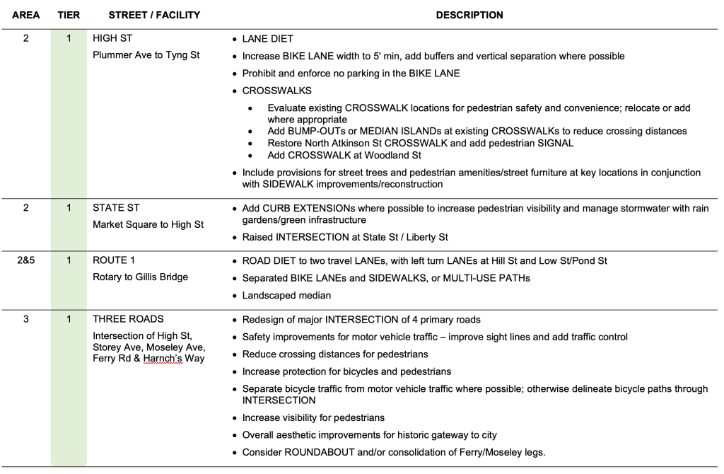
The Plan contains a detailed list of recommended improvements, ranked into three “tiers” representing relative priority:
- Tier 1 improvements are street segments and intersection improvements that close gaps in the primary circulation network, connecting Newburyport’s neighborhoods to the downtown, the schools, major recreation facilities, and the Storey Avenue shopping area.
- Tier 2 includes many of the cross streets and secondary routes that feed into the primary network.
- Tier 3 improvements are those which address minor gaps in the overall network, or where alternative routes can be used.
Here is an excerpt from the Plan to give a sense of what it contains:
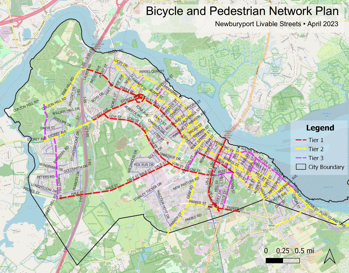
In addition to sorting by priority, the recommended improvements in the Plan are grouped into five general areas of the City. The plan is organized geographically so that residents can more easily see the types of projects and priorities in their area of the City.
The map of recommendations thus becomes a map of the City’s street network depicting priorities for actions to improve safety and connectivity for pedestrians and bicyclists.
The full Bicycle & Pedestrian Network Plan can be found here.
Related
City of Newburyport Complete Streets Prioritization Plan, March 2019
Toward a Bicycle Transportation Network for Newburyport, March 2021
Coastal Trails Network Map, 2023
