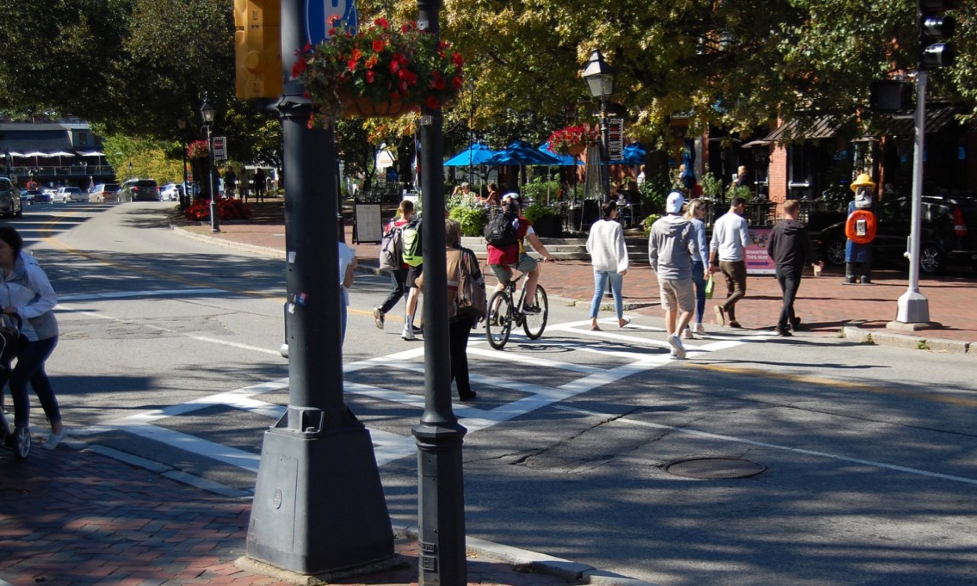
More and more residents are riding their bikes throughout the city, out to Plum Island, and to destinations in the surrounding towns. Still, some find it challenging to use their bikes for shopping trips and other types of everyday transportation. How should we think about designing a better network of bicycle routes to support everyday transportation – trips to stores, to work, to school and other destinations? Such a network would overlap with recreational cycling routes, but would be designed to make cycling an easy, safe and comfortable alternative to trips by automobile.
The blank map of Newburyport below illustrates the road network upon which the bike network would be built. It’s easy to see the main arterials that form the basis of the street network – Storey Ave, Low St, High St, Merrimac St, etc – as well as the lower-volume streets that then provide access to the neighborhoods. But this map doesn’t show which of the streets are comfortable for cycling, and where there are links or locations that are stressful and possibly dangerous for those on bicycles.

The first step in designing a bicycle transportation network is to identify the places in the city where people need or want to go. These are the same places that people go to by car, and an equitable, complete transportation system would provide safe and comfortable routes to access these places by bicycle as well. The map below identifies four broad types of destinations in Newburyport:
- Shopping/Services – Downtown ( extending to the Tannery and CVS), Storey Avenue, and the State Street/Route 1 Circle area.
- Transportation – the MBTA Commuter Rail Station and the Storey Avenue park & ride / bus stop.
- Schools/Community – Bresnahan Elementary School, Senior/Community Center, High School, Nock/Molin Middle School, Fuller Field, River Valley Charter School, and the Brown School/Youth Center.
- Parks & Recreation – Maudslay State Park, Moseley Woods, Little River Trails, Cashman Park, Bartlett Mall, Waterfront Park, Joppa Park, Perkins Playground, and other smaller facilities. Although access from the mainland to Plum Island is primarily through the Town of Newbury, the beaches and Refuge are an important recreational destinations for all Newburyport residents, so the Island is included in this category. (And the same route in reverse is the way that residents of Plum Island must use to access any of the facilities on the mainland.)

Once we know where we want to go, how do we decide what a reasonable network would be to access all these locations, that is, how dense should the network of safe and comfortable bicycle routes be? We don’t have an established standard to work with, but we can draw from the experience of other places.
The country of the Netherlands has been building, studying and refining its bicycle infrastructure for many decades, and has developed extensive standards and metrics for how to plan and design bike facilities. One of these guidelines is that a cyclist in a town or city should never be more than 300 to 500 meters (roughly 1/5 to 1/3 mile) from a safe and comfortable bike route. Using the upper limit as a guide, the map below adds two grids of 500 x 500 meters to the developed areas of Newburyport.

It’s interesting that this spacing seems to line up well with the spacing of the three major east-west streets (Merrimac-High-Low), as well as the Turkey Hill Road neighborhood in the West End. In other words, we already have the bones of a good cycling transportation network — we only have to figure out how to make it more comfortable for cyclists.
The map below adds this grid to the key destinations and gives a sense of how these destinations relate to the optimal spacing of bike routes.

The existing bicycle network is built up out of several types of facilities with differing levels of comfort and stress. The safest and most comfortable routes are those that are completely separated from vehicular traffic and include the rail trails and other off-road paths that are part of the Coastal Trails network. These are shown in the map below, and include:
- The Garrison Trail, running from the Storey Ave park-and-ride lot across the Whittier Bridge to Elm St in Salisbury, where it connects with the Ghost Trail;
- The Gloria Braunhardt Rail Trail, running along I-95 from Storey Ave to Hale St;
- The Clipper City Rail Trail, paralleling Route 1 from the Merrimack River to the MBTA Commuter Rail Station;
- The second phase of the Clipper City Rail Trail, looping from the east end of Boardwalk through the South End to Parker St;
- The Harborwalk along the River from Cashman Park to the west end of the Boardwalk.
There are plans to connect the two segments of the Rail Trail at both ends – at the north, by creating a new bike path through Market Landing Park; and at the south, by an off-road path on Parker St and improved crossings of State St and Route 1.

The next level of links in the existing bicycle network consists of quiet streets with low traffic volumes and speeds. This includes all neighborhood streets, where cars share the road with walkers and cyclists; but for the purpose of mapping transportation routes to destinations the key route shown on the map below is the series of linked streets parallel to High Street and Merrimac Street that residents call the “Middle Way”. This route is also called the “Newburyport Greenway” and described in detail here.

The Middle Way/Greenway is excellent for low-stress travel (except at a few intersections with higher-speed cross streets) but it doesn’t connect origins and destinations on opposite sides of High Street, nor does it provide connections to major destinations such as the Storey Avenue shopping centers and West End parks and recreation facilities.
Also, the Middle Way, with its many street crossings, turns and stop signs, is not as direct or quick as the major parallel routes. For example, the route from Market Square to the roundabout at Moseley Woods is about 33 percent longer following the Middle Way than along Merrimac Street (3.2 miles vs. 2.4 miles) and takes about 50 percent longer by bike (18 minutes vs. 12 minutes). As a result, it is not as useful as it could be for someone wanting to make regular shopping or commuting trips by bike.
After off-road trails and quiet streets where cyclists can easily share the road with cars, the next level of bicycle accommodation would be “protected” or “separated” bike lanes, where the bike lane has a physical separation from the vehicle travel lanes. These are common in other countries and are becoming increasingly familiar in U.S. cities, but they have not yet reached the Merrimack Valley. At this point, our only accommodations for cyclists on busy roads are the painted bike lanes on two of our high-volume/high-speed roads: High Street and outer Water Street (continuing on to the Plum Island Turnpike in Newbury). These are shown on the map below as black dashed lines.

While painted bike lanes on these busy streets are better than nothing, they do not comply with current standards for bicycle safety. MassDOT’s 2019 Municipal Resource Guide for Bikeability states that bike lanes should be used where the traffic volume is less than 6,000 vehicles per day and the operating speed is no greater than 25 miles per hour. When either of these limits is exceeded, the appropriate facility is a separated bike lane (also called a protected bike lane or cycle track). Both roads that currently have painted bike lanes well exceed these thresholds: High Street carries over 17,000 vehicles per day west of Route 1 with average speeds in excess of the 25 mph limit, and over 9,000 vpd east of State Street; and the Plum Island Turnpike carries over 10,000 vehicles per day during the summer months and has posted speed limits of 30 and 40 miles per hour. Installing a separated bike lane is challenging, but it is important to recognize that “paint is not infrastructure” and to do as much as possible to enhance the safety of cyclists.
(Even for those cyclists who are comfortable riding in the painted lanes on High Street, there is a 0.6-mile gap between Dexter Lane and Fruit Street where the lanes disappear and are replaced with shared use markings (“sharrows”), indicating that bicyclists must mix with car traffic. In addition to requiring cyclists to merge into the travel lane, this section of High St includes interactions with vehicles entering and exiting Route 1 as well as the complicated pair of intersections with Pond St and State St.)
With the combination of off-road trails, quiet neighborhood streets and painted bike lanes on two busy roads, Newburyport has the beginnings of a bicycle transportation network. However, many important destinations in the city are still not served by any bicycle accommodations. The map below shows significant gaps in the network including Storey Ave, Low St, Merrimac St, Moseley Ave, Ferry Rd/Pine Hill Rd, Hale St, Turkey Hill Rd, and Graf Rd/Parker St.

This map also highlights some key intersections that have various levels of safety issues for cyclists:
- The Three Roads intersection (High St, Storey Ave, Moseley Ave, Ferry Rd) is critical to make routine shopping trips to Market Basket, Port Plaza, etc. possible, as well as to improve connections to park and recreation facilities at Maudslay, Moseley and Cherry Hill and to the Chain Bridge.
- The Ferry Rd/Spofford St intersection is somewhat dangerous for cyclists heading west toward the Garrison Trail or Maudslay State Park because fast-moving cars have a free right turn across the cyclists’ path.
- The intersection of Low St with No. Atkinson St and Colby Farm Lane has been identified as an issue for vehicles, pedestrians and cyclists.
- The intersection of Merrimac St with Winter and Summer Streets and the Route 1 ramps
- The Route 1 Circle is a major challenge for cyclists in all directions. There are plans to improve the east-west crossing between the two sections of the Clipper City Rail Trail, but no current plans to make any of the north-south cycle routes safer.
- The intersection of Plum Island Turnpike with Old Point Road and Sunset Drive is in Newbury, but is important to Newburyport residents as part of the route to Plum Island Point as well as to the beach in Newbury and the National Wildlife Refuge.

Newburyport’s Complete Streets Policy commits the City “to provide safe and accessible
options for all users and travel modes, so that pedestrians, bicyclists, motorists, and public transportation users of all ages and abilities are able to safely move along and across a street or street network.” To fulfill this commitment, we need to find ways to build out the network so that the gaps shown on this map are eliminated and residents who want to use their bicycles for ordinary transportation are able to do so.

Excellent post, thank you for the in depth analysis and great maps. Link to the Greenway presentation too!
LikeLike
Thank you! I love all the information abs it very easy to read.
LikeLike
Well done. Every bike on the road means one less car.
Thanks for doing this.
LikeLike
Your post is terrific but some crucial information is missing. The MVRTA has (2) bus routes in Newburyport, route 54 and route 57. Route 57 circulates downtown every 30 minutes. All MVRTA vehicles are equipped with bike racks that carry two bikes. It is sometimes helpful to extend your trip further by using the bike-bus connection to close the gap safely between destinations. Transit buses can help residents feel safe while still providing access to critical services. Complete streets are important policies to support multi-modal transportation.
LikeLike
This post focuses on cycling, but walking and transit are also important elements of the City’s transportation system. Using the bike racks on MVRTA buses can help riders avoid some route sections that don’t feel comfortable or safe. We have links to the MVRTA routes on the “Newburyport and Region” page (https://newburyportlivablestreets.org/local/).
LikeLike
One aspect has been omitted in this admirably researched and executed study: the horrid condition of the pavement of many streets in Newburyport. Even many streets in the Mid Way section have poor pavement.
I have had my share of punctures, a broken axle, a bent pedal, a head light broken off the handle bar, all as a result of pavement conditions.
I like to express my gratitude to all motorists, not a single exception, that show concern for my safety while sharing the road with me.
However, I regularly observe cyclists violating basic rules of the road: riding on the left side, no signaling, blowing through red lights, riding without lights in darkness!!
Many thanks to the people who researched the data and assembled the maps in this study.
LikeLiked by 1 person
The Port Plaza complex (where Market Basket and Shaws are) lacks bike lanes. The whole layout is bike antagonistic.
LikeLike